 |
| Climb to Mt. Tengudake, massive Mt. Ioudake on the left and the peak of Akadake shows its top over the Mt. Ioudake |
 |
| All members at the top of Shirasuna Shindou |
月一で台湾の山を道案内している慢集團の初めての海外登山の試みとして、日本の八ヶ岳を訪れた。去年、
単独で歩いた縦走路に加えて天狗岳など北八ヶ岳の部分も含め、二泊三日の山の旅である。今年は、太平洋高気圧の勢力が強くなく梅雨明け後も天候が安定せず、初日は雨の中の赤岳登山となったが、その後持ち直し最後は快晴のもと素晴らし景色を満喫できてよかった。日本一高い位置にある本沢温泉の露天風呂など、日本の高山登山の醍醐味を味わえたと思う。すでに中国語での記述があるので、最後一日は異なるものの、今回は英語で記述する。
================================================================
 |
| Start from Minotguchi at the lower left, going over the main ridge and down to shibunoyu on upper center |
 |
| Elevation profile of the three-day trekiing |
I take a group of
Manjituan hiking club (慢集團) to hiking over mountains and hills near Taipei almost once every month. This time the destination is not within Taiwan but my home country Japan. The club has never done an overseas expedition in the past and the first honor was given to me as an organizer and a leader of the troop. Fourteen people joined the expedition and made an three-day successful trekking over the mountains of Japan.
 |
| First day at the trail head |
Like Taiwan, Japan is a mountainous country where approximately 70% of its territory is covered with mountains low and high. Though the tallest mountain belongs to Taiwan,
Yushan (玉山), Mt. Jade, and there are more peaks of 3,000 meters and over in Taiwan, the range of mountains is larger in Japan. The highest peaks of Japan are located in the central region of the main island. There are three major mountain ranges and one smaller yet tall range called Yatsugatake (八ヶ岳) peaks. Yatsugatake in Japanese means eight peaks, but it does not mean here that there are only eight but many. It is consisted of the highest peak Mt. Akadake (赤岳) with elevation of just one meter shy of 2,900 m and its adjacent peaks are also in 2,600 ~ 2,800 meter range. A single range of peaks in row goes from north to south and is easily accessible from either side. There are many mountain lodges and accommodation facilities over the entire range which makes long hiking easier and safer. The trails are well maintained as well. So this is an ideal destination to introduce the high mountains of Japan. This is a reason why we visited Yatsugatake this time. I
visited a part of the range last year and updated my experience with this area too, which accounts for another reason.
 |
| At the summit of Mt. Akadake |
 |
| Open-air hot spring bath and Mt. Ihoudake |
We started from Taipei on July 22 and stayed in Tokyo over a night. We took a chartered bus to the trail head in early morning of the next day. We climbed to the top of Mt. Akadake where a lodge is located and stayed overnight. On July 24, we made a trekking over the range of peaks, passing over Mt. Yokodake (橫岳) and Mt. Ioudake (硫磺岳) and went down to a hot spring lodge, Honzawa onsen (本澤溫泉 ). Members enjoyed the hot spring and went up again to Mt. Tengudake (天狗岳) in the next morning of July 25. The weather finally turned to be cloudless blue sky and we enjoyed gorgeous view from the summits as well as while we are walking. After we took a round trip to Mt. Nakayama (中山) and descended to Shibunoyu (渋の湯) to conclude our trekking activity. We went back to Tokyo and the members returned to Taiwan on July 26.
In three days we covered approximately 26 kilometers of distance. The total height we gained is about 2,400 m. I am really glad to find that all members were very happy after the expedition was over though there was a tough time during the activity. I believe that the mountains in Japan offers a different kind of natural charm than Taiwan. I hope that there will be more chances to share this with my friends of Taiwan in the future.
-----------------------------------------------------------------------------
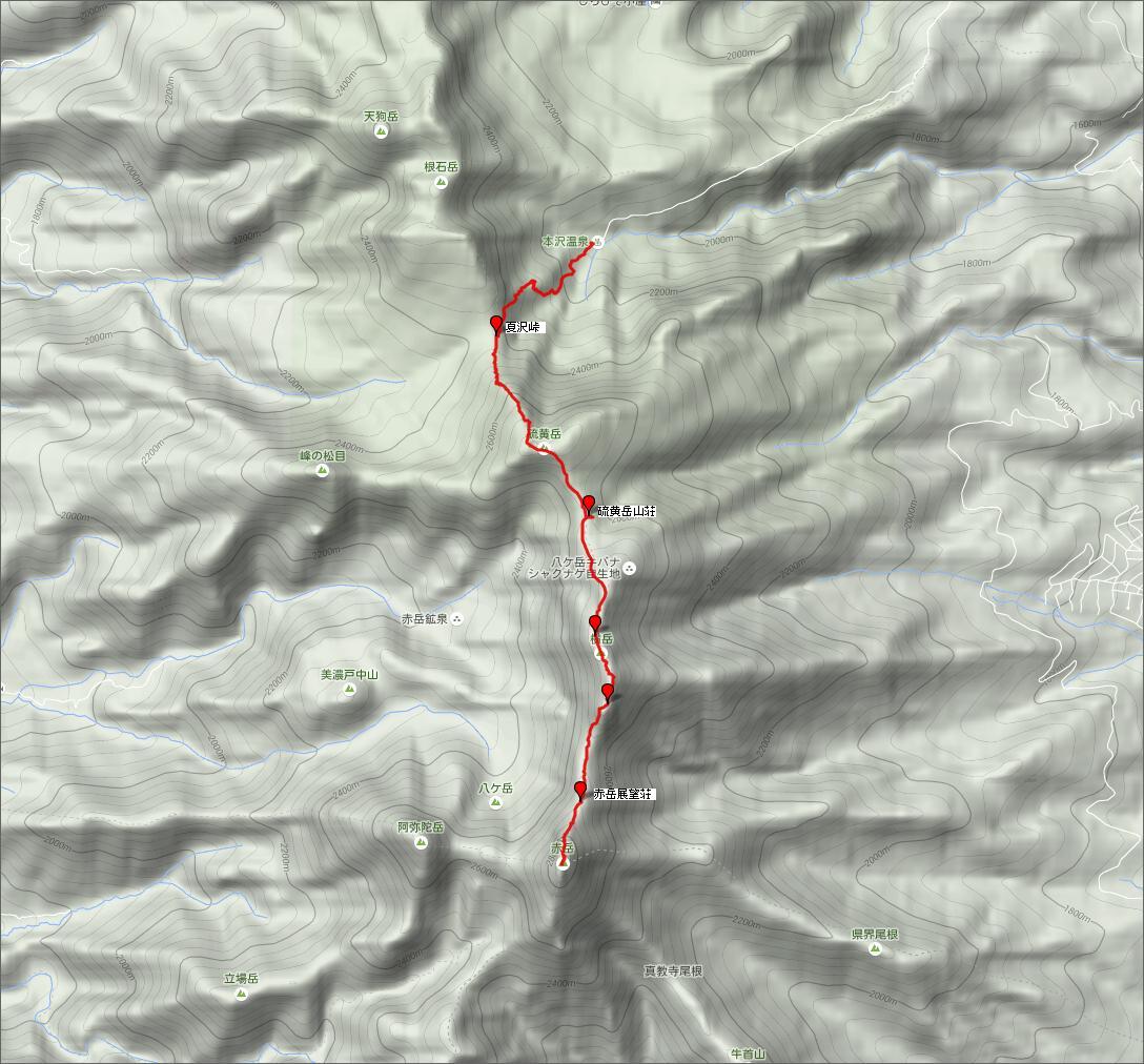
First day July 23 Tokyo - Minotoguchi trail head (美濃戶登山口) - Gyojagoya (行者小屋) - Bunzaburo ridge trail (文三郎尾根道) - Mt. Akadake (赤岳)
 |
| The first day is just climbing to Mt. Akadake |
 |
| Only uphill |
 |
| Driving on highway to the trail head |
14 of us had come from Taipei yesterday afternoon and stayed at a hotel in a suburb of Tokyo. We then came by a chartered bus that we booked in a few months in advance all the way to the trail head here at Minotoguchi a little after 9:00. It took us three hours to have come here. After we passed Sasago (笹子) tunnel and entered into Kofu (甲府) district, it started rain. It is still raining here and this is, honestly speaking, disappointing. We have come such a long way but the Yatsugatake showed such a nasty weather to us.
 |
| Crossing the rapid stream over a bridge |
 |
| Going up from the Minamisawa main streem |
Whatever the weather it is, this is our hiking and we have to move. We have another members who joined us in Tokyo and now we have 15 members in total. We all put on rain wear in front of Yatsugatake lodge (八ヶ岳山荘) of Minotoguchi. We place our first step of the three-day trekking a little after 9:30. Fortunately the rain is light and an umbrella is good enough to walk on a wide dirt road leading to Akadake sansou (赤岳山莊). I post our trekking plan into a box in front of the house. Unlike Taiwan, there is no control of entering high mountains in Japan, but it is strongly recommended to leave a plan just in case.This road is only open for small cars and even a small bus that we took cannot come in. After a little downhill and passing over a creek with rapid stream, we start going up. Where the road takes a zigzag, we take a short cut. At 10:17 we come to Yamanokomura (やまのこ村) and Akadake Sannsou. We go into the house of Yamanokomura. A few of our members buy some souvenirs there.
 |
| Crossing a sub stream |
 |
| Passing by the old stone shrines |
After a short rest we resume our walk and come to Minotosansou (美濃戸山荘) where the hiking trail diverges. We take a right (south) trail which leads to Gyojagoya (行者小屋) along the creek of Minamisawa (南沢). A dirt trail is well maintained, though rocks are all over. We cross the rushing stream twice over a bridge and take a rest at 11:30 just blow a steep uphill. From here the trail goes up and leave the water stream behind. The trail goes round a bend and meets a sub stream where we take a rest at 12:20. We cross the small creek and up go along it. In 10 minutes or so we come to a small shrine which is placed on the mountain wall. This Yatsugatake is originally a place of religious worship and monks came for their training centuries ago. We cross the stream several more times and up come to where no water is visible. We go into a forest and come out again into a wide dry riverbed. If the weather is good, you can have a view of Mt. Akadake, which is completely in clouds now.
 |
| Gyojagoya in thick fog |
 |
| Going up on a steep grade |
We pass the heliport at 14:00 and arrive at Gyojagoya at 14:05. We are a little behind my original plan but it is still OK. We have a good rest as we need to climb the steepest trail today to the peak of Mt. Akadake later. Some members buy sweet food at Gyojagoya lodge, which make them warm and happy. It is still raining and the thermometer shows 16 degree C. Just a little before 15:00 we start our last leg of today's hike. There is 550 meters gap in elevation here and our destination. We first walk along a dry creek and come to a junction in about ten minutes. We take the left one while the right trail leads to Mt. Amidadake (阿弥陀岳). The trail gains grade and it becomes harder to go up. Metal steps appear in the middle of the trail and up we go on it. The mist is pretty thick and the visibility is very low. We take a rest at 15:40 where surrounding trees are all short. We have reached the timberline.
 |
| Climbing steps in the thick mist above timberline |
 |
| Good food after the all-day climb |
We are more exposed to rain and wind because we are out of woods. We finally reach the ridge between Mt. Akadake and Mt. Nakadake (中岳) at 16:30. The wind gains more power and it becomes much harder to walk. The upper section below the peak is more difficult as it is a very steep rock route. I am concerned with members' safety. They are experienced hikers and we all pass the section without problem and reach the peak. There is no view to see there and we keep on to the Akadake Choujou Sansou (赤岳頂上山荘). As soon as we step in the lodge before 18:00 all members find it very cozy and are happy. We have a little late dinner at 18:30. The guests are not many today and there are 10 or besides us. We go to bed at 20:00 as it is the time light goes out. We walked approximately 9 km and gained the height of 1,400 meters today.
---------------------------------------------------------------------------------
Second day July 24 Mt. Aadake (赤岳) - Mt. Yokodake (橫岳) - Mt. Ioudake (硫磺岳) - Natsuzawa overpass (夏沢峠) - Honzawa onsen (本澤溫泉 )
 |
| Walk from south to north |
 |
| Start from the highest point to Honzawa Onsen |
 |
| Summit of Mt. Akadsake, South Alps peaks are behind |
The weather is still foggy when we wake up around 5:00 in the morning. The two of members stayed at Gyojagoya yesterday as they fell much behind the rest of us and returned to Gyojagoya for a safety reason. They will join us later today. I set our departure time 7:00 because the two members need to climb up to the ridge. When we go out around 6:30 after breakfast, blue sky is visible though cloud is moving very fast. We are prepared to today's hike around 7:00. When I step out the house, to my surprise the two members are coming up from the other side of the peak. We originally planed to meet at the junction of Jizou ridge route (地蔵尾根) but they started from Gyojagoya at dawn and have come all the way up to here. Anyway it is good to have all members together.
 |
| Looking north from Mt. Akadake, a peak of Mt,.Yokodake in coulds |
 |
| The author on the top of Mt. Akadake |
All members take pictures at the peak of Mt. Akadake just across the lodge. This is the highest point in our three-day trekking. Over the sea of clouds, peaks of the South Alps Mountain Ridge (Akaishi mountain range 赤石山脈) appear and hide soon. Mt. Fuji shows its part just for a few seconds. At 8:00 we start our walk on the ridge route today. We go down steep decent and reach Akadake Tembousou (赤岳展望荘) lodge at 8:36. We take a first rest by the lodging house. As we go along the ridge route, we find Komakusa (駒草) flowers by the trail side. Some of them are white, which are rather rare. Komakusa plants live on very poor soil where other vegetation is rare. They were once used as medicine and at some places almost extinct. Through the past few decades of preservation effort they are now back and thriving.
 |
| Members ready for hike in front of the lodge |
 |
| Jizou junction |
The ridge gets narrower and at 9:00 we come to the top of Jizou ridge trail. There is a small stone Buddha statute and the trail is named after it. Here we start to walk on the trail of Mt. Yokodake. Mt. Yokodake is a series of peaks with a highest peak of elevation 2829 m near its end. It goes by very deep cliffs and some dangerous sections. The fog is now thick and we cannot see any view. The visibility is just 10 meters so around. At 10:30 we pass Mt. Sanshaho (三叉峰) where a trail going down to Kiyosato (清里) at the mountain foot diverges. We further climb a section of steel steps and reach the highest peak of Mt. Yokodake at 10:50. We have a long rest here. While we are resting, a family of the aged and the very young come up. Our members chat with them and take pictures with them.
 |
| Going on the rock ridge |
 |
| Members at the top of Mt. Yokodake |
 |
| Komakusa flowers |
The section of descent from the peak is also precarious and we all go down very carefully. After this section is over in about 20 minutes, the trail becomes wide and easy. The both sides are field of Komakusa flowers and they are protected by nets and ropes. We come down to Ioudake Sansou (硫黄岳山荘) lodge at 12:35. We have lunch break in front of the lodge. This is the lowest point between Mt. Yokodake and Mt. Ioudake (硫黄岳). We have come about a half of today's course. Fog is clearing and we can see the foot of the mountain once in a while.
 |
| Going by the stone pile |
 |
| Mt. Ihoudake summit |
We resume our walk at 13:50. Cloud surrounds the mountain at this height and over and as we ascend to Mt. Ioudake, we come into fog again. Big stone piles are placed at an every distance visible even in thick fog and we follow them, otherwise the very wide ridge may misguide you to a wrong place in dense mist. The grade is rather easy and we arrive at the wide summit of Mt. Ioudake at 14:25. This is the last peak in today's hike.
 |
| View from the downhill to Natsuzawa Touge pass |
 |
| Honzawa Onsen is visible in the forest |
There is another trail going left which leads to Akadake Kousen (赤岳鉱泉) and then to Minotoguchi trail head. We take right and go down to Natsuzawa touge (夏沢峠) pass. As we go down, we come under clouds and a wide view spreads out in front of us. This is the first such sight of far away view in our trekking up untill now and we all get excited about it. We go further down and from an edge of the deep cliff we can see the black roof of Honzawa Onsen (本沢温泉) in the thick forest and even an open air bath near it. That is our destination today.
 |
| Going down from Mt. Ioudake |
We go down into a forest again at 15:12 and reach Natsuzawa Touge pass in about 10 minutes. This is an intersection with four different destinations. There are two different lodges here, Yamagiko Sou (山彦荘) and Hutte Natsuzawa (ヒュッテ夏沢). The Yatsugatake is full of commercial lodges and that makes trekking over here is easy and safe. After a short rest we start our final leg of the walk down to Honzawa Onsen. The descent in the forest is easy compared with the course that we have walked so far. We arrive at Honzawa Oncen at 16:23.
 |
| Walking down in the forest |
 |
| The dinner at Honzawa Onsen |
Honzawa Onsen is a natural hot spring discovered and opened for service in 1882. The lodge is open throughout a year, though you have to but walk to get there. There are two hot spring bathes, one in the lodge house and the other open-air one up in the valley. The chemical of the water is different at each bath and you can enjoy the two different kinds of water. The open-air bath is called Yunjou no Yu (雲上の湯) and is said to be the one located at the highest location in Japan. Before the dinner at 17:30 we take the in-house hot spring bath. The water is rather hot but it is very good after a day long walk. In order to protect environment, it is suggested not to use any soap when you wash. Even toothpaste should be refrained. The dinner is very good. Vegetables all come from a farm of the lodge. I take the in-house bath again and enjoy beer with some members in the front yard after that. All light goes out at 20:00 at this place too.
-------------------------------------------------------------------------------------------
Third day July 25 Honzawa Onsen (本沢温泉)- Shirosuna Sindo (白砂新道)- Mt. Tengudake (天狗岳)- Tengu no Okunoin (天狗奥院) - Kuroyuri Hutte (黒百合ヒュッテ) - Nakayama (中山) - Sibunoyu (渋の湯)
 |
| Start from east, across the peaks to west |
 |
| Crossing over the peaks |
 |
| Going to the open-air bath after dawn |
I woke up before dawn. This is because I promised with some members to go to the open-air hot spring before breakfast. When we go out the house around 4:30, the sky is clear and a good weather is promising. We walk up the trail that we took down yesterday and come up to a junction to the bath. We take left and go down to the valley where the small bath is. It is just a few minutes of walk from the lodge. The bath is just besides the valley stream and the whole nature surrounds it. High up in the valley Mt. Ioudake that we climbed yesterday is commanding over. 6 of us take a leisurely hot spring bath of white water. This one is mainly of sulfa substance while the in-house bath is of salt substance. Other guests come too and the small bath is now full of people.
 |
| The members are ready for hike in front of the lodge |
 |
| Going up in the forest |
Back at the lodge we have a breakfast at 6:00. We have a long way today and get ready for the hike in a hurry. We take off a little after 6:30. The sun is out up in the sky and we are all exited. At the end of the lodge area we take another route called Shirosuna Shindo trail (白砂新道). This trail leads to a ridge between Mt. Neishidake (根石岳) and Mt. Tengudake (天狗岳). Soon a steep ascent starts in the forest. The forest is actually an important attraction of the Yatsugatake. Shirabiso (Veitch's silver fir) trees are all tall and green moss covers the forest bed. If you stop walking, only silence surrounds you. Though steep the trail is, its condition is very good and easy to walk on.
 |
| Going through beautiful woods |
 |
| We are coming out of the forest |
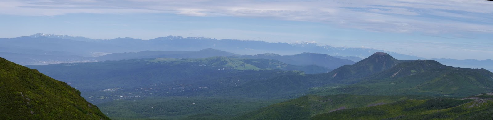
At 7:25 we get on to a sub ridge extending from the main ridge. We have come up 3/4 of the route up to the main ridge. We then go down a little passing a mushy section. Another steep climb begins. After seeing a sign board saying another 15 minutes to the ridge, the trees in the forest show change, now Dakekanba (Erman's birch) trees take over Shirabiso trees. Soon we come out of the forest and a wide view spread out in front of us. At 8:30 we arrive at the ridge and find wind is very strongly blowing through. We are all happy to see a splendid view is just there. On our right stands Mt. Tengudake east peak with an adjacent west peak and on our left Mt. Neishidake. If looking back the direction that we have come, peaks after peaks continue endlessly beyond the valley. On the other side you can see Mt. Ontake (御嶽山) which erupted last year in the distance beyond the Kiso mountain range, or the Center Alps range (木曽山脈). We are finally awarded a wonderful weather!
 |
| Viewing the direction of where we coming up |
 |
| The other side, Mt. Ontake is visible far in the distance |
 |
| Our members are walking on the ridge |
The wind is so strong that all members take out wind jackets and put them on. We start a climb towards the east peak of Mt. Tangudake. We are above the timberline and everything is so clearly visible. As we go up on the white gravel trail, more view spreads out. Now we can see the triangle shaped Mt. Amidadake just over Mt. Neishidake and Mt. Akadake shows its top just on the right of the massive Mt. Ioudake. Passing over a steel bridge that goes over the sharp edge, at 9:15 we reached the summit. There are several hikers on the top. The narrow summit is full of people including our members.
 |
| At the summit of Mt. Tengudake |
 |
| Panorama view to the south |
 |
| Viewing north |
At 2,649m high, Mt. Tengudake is not the highest peak of the Yasugatake, but its center location of the mountain range gives a wonderful vantage point of simultaneous observation on both the North and the South Yatsugatake. The Yatsugatake is divided into two sections, north and south. While the north section or North Yatsugatake is a land of thick forests, the south section is a land of rocks. The peaks in the North Yatsugatake are lower and their shape is gentle. The South Yatsugatake where we have walked through in the last two days is characterized with ragged rock peaks and pointing summits.
 |
| The view of North Alps range |
 |
| Going down a steep rock section |
The summit gives a great view of not only the Yatsuagtake range, but also all mountains and peaks all around. You can see all of the South, Center and North Alps ranges. You can make out snow on the North Alps peaks. Lake Suwa (諏訪湖) shows its water surface in front of Mt. Norikuradake (乗鞍岳), another member of the 3000m peak club.
 |
| Kuroyuri Hutte and Okunoin are just down below |
We enjoy the view for a half hour and starts descent. We carefully walk down the rock section and come to a junction at 10:06. The trail on the right goes down to Nakayama touge (中山峠) pass while the left one goes through Tengu no Okunoin (天狗奥の院)and leads to Kuroyuri Hutte (黒百合ヒュッテ) lodge. Under the clear sky all trails and the lodge of Kuroyuri Hutte are visible in front of us. We take left and keep decent. Soon big rocks appear on the trail, which is why this section is called Tengu no Okunoin. Tengu is a imaginary creature with super physical power and they supposedly come here and jump on rocks for fun. It is not easy for us, normal human, to walk through this section.
 |
| Waling towards rocky section of Okunoin, The flat mountain in the distance is Mt. Nakayama |
 |
| Going among big rocks |
There are small ups and down in this section and it takes time to go through. A little after 11:00 we come to the side of Suribachiike (摺鉢池), a small pond in the depressed area surrounded by stone walls. Now the peak of Mt. Tengudake is far in the distance. We start descent to Kuroyuri Hutte and arrive there at 11:33. Many hikers are resting in front of the lodge. We also take seats and have lunch that we got at Honzawa Onsen. It is warm here under the noon sun.
 |
| Suribachi Ike and Mt. Tengudake |
 |
| Kuroyuri Daira and the lodge |
Our final destiantion, Shibunoyu is reachable from here. Our original plan is to keep on the trail to Takamiishi (高見石) but it would be too long if we go that way and we would not make it by 17:00, the time when the chartered bus picks us up there. So I change the plan and decides to go down directly to Shibunoyu. However there is still more time and we make a round trip to Mt. Nakayama first. Two of us do not go and keep watch on the backpacks. The rest members start at 12:23 without a heavy backpack for Nakayama Touge first. We go through woods where wood panels are laid on the trail to protect the forest bed. In a few easy minutes we come to Nakayam Touge pass where four trails meet.
 |
| Passing by an area of dead trees |
We take left and walk on the ridge trail. At 12:34 we come to a open platform where we can see the peaks of Mt. Tengudake. The trail goes through woods. The grade is very moderate and we are happy to follow the trail. We come to a junction to Nyu (にゅう) at 12:42 and take left. We go by an area of dead trees. A band of trees go dead for some reason which is not fully identified. Baby trees will take over the area but the band goes up along the slope year after year. This is a phenomenon called wave regeneration and only occurs to the spices of Shirabiso (Veitch's silver fir) trees. We further go up along the trail and at 12:56 reach the flat summit of Nakayama (elevation 2,496 m). The summit mark is just by the trail and surrounded by trees.
 |
| A view from the vantage point just below the summit of Mt. Nakayama |
 |
| Nakayama Touge Pass |
We keep on the trail for anther few minutes and come to a wide open area with bunch of rocks. This is a good vantage point. A conspicuous peak of Mt. Tateshina (蓼科山) is just at the end of the mountain range. This is the furthest point of our trekking. We spend good 15 minutes to enjoy the splendid view and take the original trail back. We climb back a little to the summit of Mt. Nakayama and descend the rest of the way to Kuroyuri Hutte. We are back at the lodge at 13:58. The thermometer on the lodge entrance shows 21 degree, which is pretty warm up in the mountain.
 |
| The trail is full of big rocks |
At 14:13 we start for the last leg of our three-day trekking. Today is Saturday and many hikers are coming up and meet us. The trail goes along a valley and full of big rocks. Some parts are covered with wood plates. At some sections there are two parallel paths, one at the bottom of the valley and one at the mountain side. The latter is for winter and when the creek water is too much. At 15:09 we come to a junction to Karasawa Kosen (唐沢鉱泉). We take right here and go up a little and then start a moderate downhill. At 15:35 we come to another junction. There is a road sign but the letters on it are faded and almost unreadable. We take right here and a steep descend lasts for twenty minutes or so. After passing another junction of a trail leading to Takamiishi, we finally reach the trail end just across a stream at 16:27.
 |
| At the trail end (picture by Vincent) |
This is the end of the first expedition of the club. We are all safe and happy. Going a littler further down the road and come to a front of a hot spring resort Shibugotenyu (渋御殿湯). The chartered bus is supposed to show up at 17:00. We wait for it in front of the house. 17:00 passes but no bus shows up. We contact the bus company and find that they have sent the bus to a wrong place. We wait for another hour and half and finally the bus comes. On the way down, the mountain peaks that we have walked in the last three days are just there visible through bus windows as if saying goodbye to us.
 |
| The peaks of Yatugatake, where we trekked for three days |


0 件のコメント:
コメントを投稿